British trivia
Home page
Last update:
15-Nov-2004
©1996-2007
Mike Todd
Broadcasting
House
Long before radio was invented
The maps included here are derived from old maps of the time, with the main present-day streets overlayed in red and Broadcasting House in blue. The old maps are only approximations, although I've tried to get them as accurately scaled as I can within the time available.
The
Tyburn estate
This north part of London was once bounded by Roman roads to the east
and west, and split in two by the Tybourne river. The Domesday Book records
that the manor of Tyburn consisted of no more than 150 people, and was
worth 52 shillings.
In 1241, St John's church was built where Vere Street is now, but this was later replaced in around 1400 by a church further upstream on the Tybourne. This church was St Mary's, and the area soon became known as St Mary's on the Bourne. This was later to become St Mary-la-Bourne (following the fashionable name of St Mary-le-Bow), which in turn was shortened to St Marylebone. Of course, in those days, spellings varied, sometime arbitrarily ... Tybourne was sometimes Tyburn or Tiburn, and Marylebone was variously Mary-le-burn, Mary-la-bonne, Mariburn and even Marrowbone.
Down in the south-west corner of the area, more or less where Marble Arch now stands, was the Tyburn Tree, otherwise known as the Middlesex Gallows, and the remainder of the estate was a popular hunting ground. There are numerous references on the Web to this hanging place, but one, about Public Execution in Early Modern England, and an Online History, both make good starting points.
When Henry VIII bought the Tyburn Estate in 1544, he had a hunting lodge built where the north end of Harley Street and Devonshire Mews now are. The manor was passed around over the years, but the hunting grounds remained with the Crown.
By the start of the 17th century, the area was still separated from the rapidly expanding London (with Soho Square at its northern limit) by a strip of about half a mile.
It might be imagined that this entire area was very quiet, and only the gentry would be seen. But to the south there was a very busy pathway carrying traffic to the gallows at its western end and cattle to Smithfield Market to the east. Execution Day and Market Day often coincided, and this road (the west of which was called Tyburn Road, later Oxford Road and now Oxford Street) was often reported to be very heavily congested as early as 1614. The congestion got worse over the next hundred years or so, and eventually (in the 1750s) a bypass for Oxford Road was built. This road (called New Road) was built to the north, and had numerous toll houses on its route - this road is now Marylebone Road.
Marylebone
Fields - the 18th century
Although the area was growing rapidly, much of Marylebone in the early
18th century remained occupied by fields and farms, sometimes collectively
known as Marylebone Fields.
To the south-east of where Broadcasting House now is was Night Pit Field and Dung Field, where the nightman would empty his buckets filled with the sewage he had collected from the rich folk's homes. If you weren't rich enough to afford his services, you'd simply have thrown the sewage into the street.
The road on the map that appears to run along Oxford Street is the path that used to run from St Giles to the south-west up to St Mary by the Bourne.
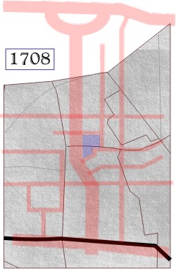 But
1708 was an important year for the area: the Tyburn estate was sold to
John Holles, the Duke of Newcastle. This represented the start of urbanisation
of this part of London. Although development did not start immediately,
it is possible that Holles had already started planning the magnificent
square that was to bear the family name of his wife, Margaret Cavendish.
But
1708 was an important year for the area: the Tyburn estate was sold to
John Holles, the Duke of Newcastle. This represented the start of urbanisation
of this part of London. Although development did not start immediately,
it is possible that Holles had already started planning the magnificent
square that was to bear the family name of his wife, Margaret Cavendish.
The estate was passed to John Holles' daughter, Henrietta Cavendish Holles, in 1711. She in turn married Edward Harley, 2nd Earl of Oxford, and the entire estate became known as the Harley-Cavendish estate.
In researching this family connection, I discovered that there is evidence that they share an interesting connection with Prince Charles and Camilla Shand (later Mrs Parker-Bowles).
John Holles and Margaret Cavendish appear to have been Prince Charles' 7th-great-grandparents, and Henry Cavendish (Margaret's father) was Prince Charles' 8th-great-grandfather and Camilla's 9th-great-grandfather!
I should stress that this has been found on the Web, so I can't claim it to be completely accurate!
Anyway, it wasn't long before Edward Harley had formulated big plans for the area.
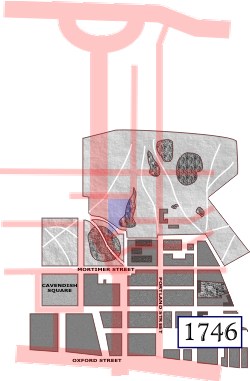 By
1719, Cavendish Square had been laid out. Harley's plans for the area
(drawn up by architect, John Prince) showed a magnificent mansion along
the north side of the square.
By
1719, Cavendish Square had been laid out. Harley's plans for the area
(drawn up by architect, John Prince) showed a magnificent mansion along
the north side of the square.
It was to be built for the First Duke of Chandos, and called Chandos House. Stretching across the whole block from Harley Street to Chandos Street, the idea was to provide an imposing view as one came up Holles Street from from Hanover Square, south of Oxford Street.
By 1746 only some of these ideas had been realised, and this Chandos House itself was never built. Although the main wall and gate of Chandos House did get built, along with a house at each end (on the corners of Harley Street and Chandos Street). the wall was soon demolished and two smaller mansions were built between the two houses.
This Chandos House shouldn't be confused with the Chandos House that was built by Robert Adam for the Duke's grandson in 1769, and which still stands on the north side of Queen Anne Street, at the north end of the present-day Chandos Street.
The area occupied by Broadcasting House, in fact most of the area north of Mortimer Street, remained as fields or park land.